Modelling Phosphorus Concentrations in the North Basin of Windermere
The Project
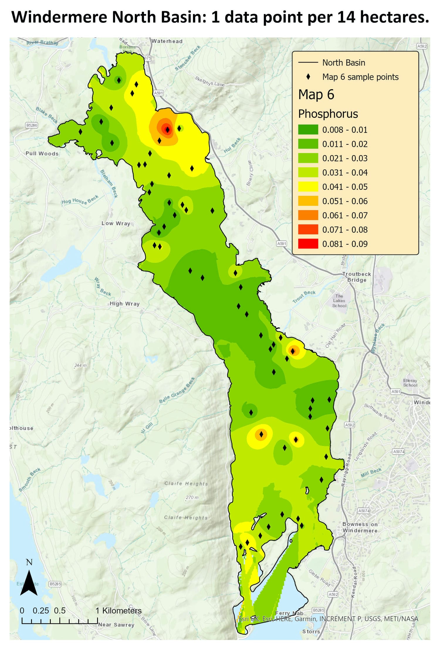
This project explores how increasing sampling resolution improves the spatial understanding of phosphorus concentrations in Windermere’s North Basin. It addresses gaps in existing data by assessing whether shoreline sampling accurately represents conditions across the whole basin and how additional sampling points change the resulting spatial patterns.
Phosphorus is a key indicator of eutrophication and was chosen to better understand nutrient- driven water quality issues within Windermere.
Background
Windermere is England’s largest natural lake and is environmentally, culturally, and economically significant. Naturally, it would be classified as oligotrophic, with low nutrient levels and rare algal blooms. However, recent years have seen frequent eutrophication events and potentially toxic algal blooms, raising concerns about the lake’s ecological health.
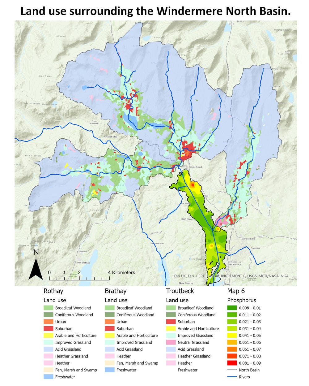
While Windermere has been widely studied (including research on rare species, lake morphology, and catchment processes), recent attention has focused on nutrient pollution. Phosphorus inputs from wastewater treatment works operated by United Utilities have been identified as a major contributing factor.
What I Did
Stratified random sampling was used to collect unbiased water samples across the North Basin. Phosphorus concentrations were analysed using GIS and supported by statistical regression analysis to assess spatial patterns and data representativeness.
The Project
This project explores how increasing sampling resolution improves the spatial understanding of phosphorus concentrations in Windermere’s North Basin. It addresses gaps in existing data by assessing whether shoreline sampling accurately represents conditions across the whole basin and how additional sampling points change the resulting spatial patterns.
Phosphorus is a key indicator of eutrophication and was chosen to better understand nutrient-driven water quality issues within Windermere.
Background
Windermere is England’s largest natural lake and is environmentally, culturally, and economically significant. Naturally, it would be classified as oligotrophic, with low nutrient levels and rare algal blooms. However, recent years have seen frequent eutrophication events and potentially toxic algal blooms, raising concerns about the lake’s ecological health.
While Windermere has been widely studied — including research on rare species, lake morphology, and catchment processes — recent attention has focused on nutrient pollution. Phosphorus inputs from wastewater treatment works operated by United Utilities have been identified as a major contributing factor.
What I Did
Stratified random sampling was used to collect unbiased water samples across the North Basin. Phosphorus concentrations were analysed using GIS and supported by statistical regression analysis to assess spatial patterns and data representativeness.

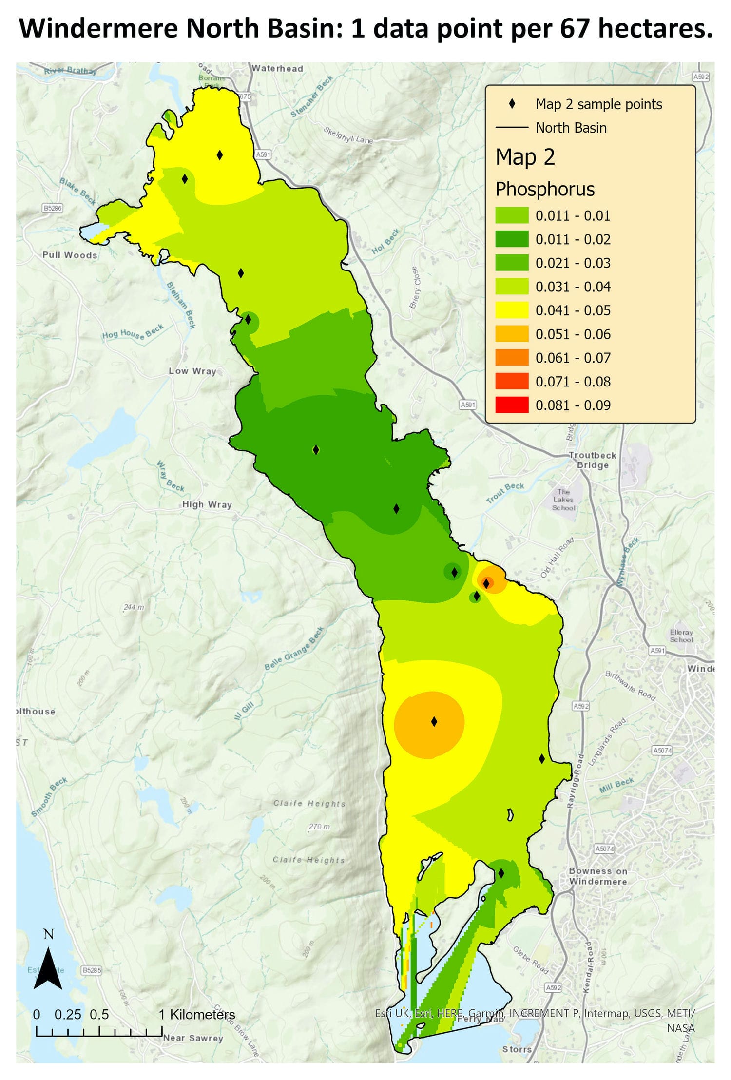
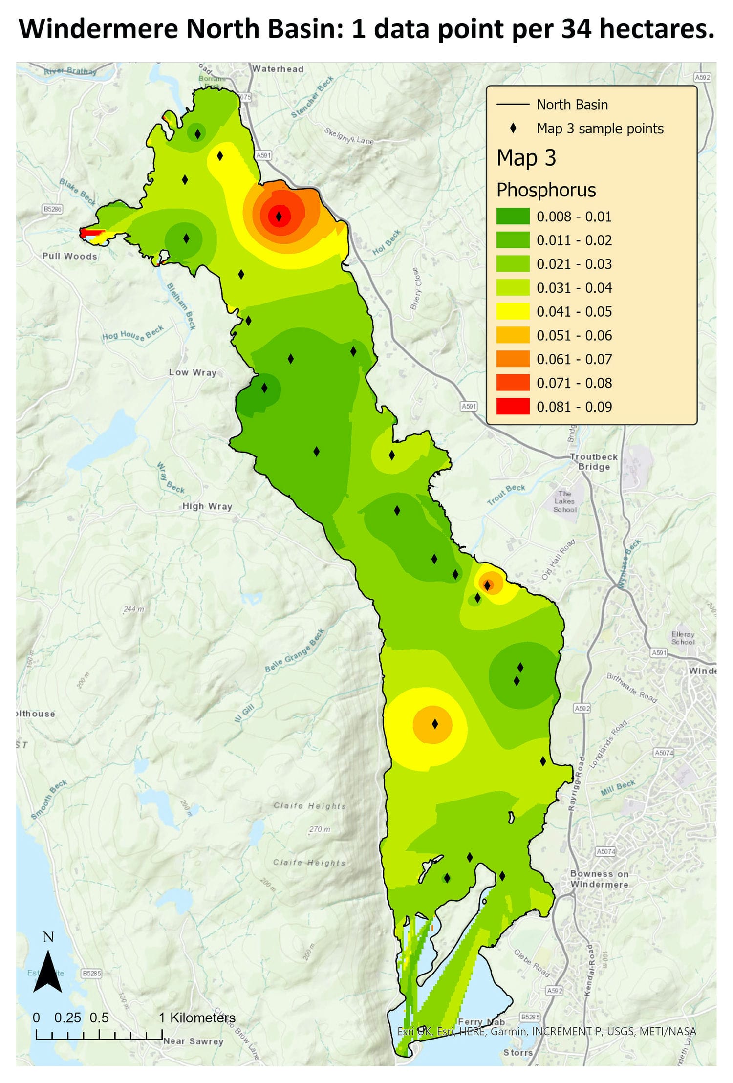
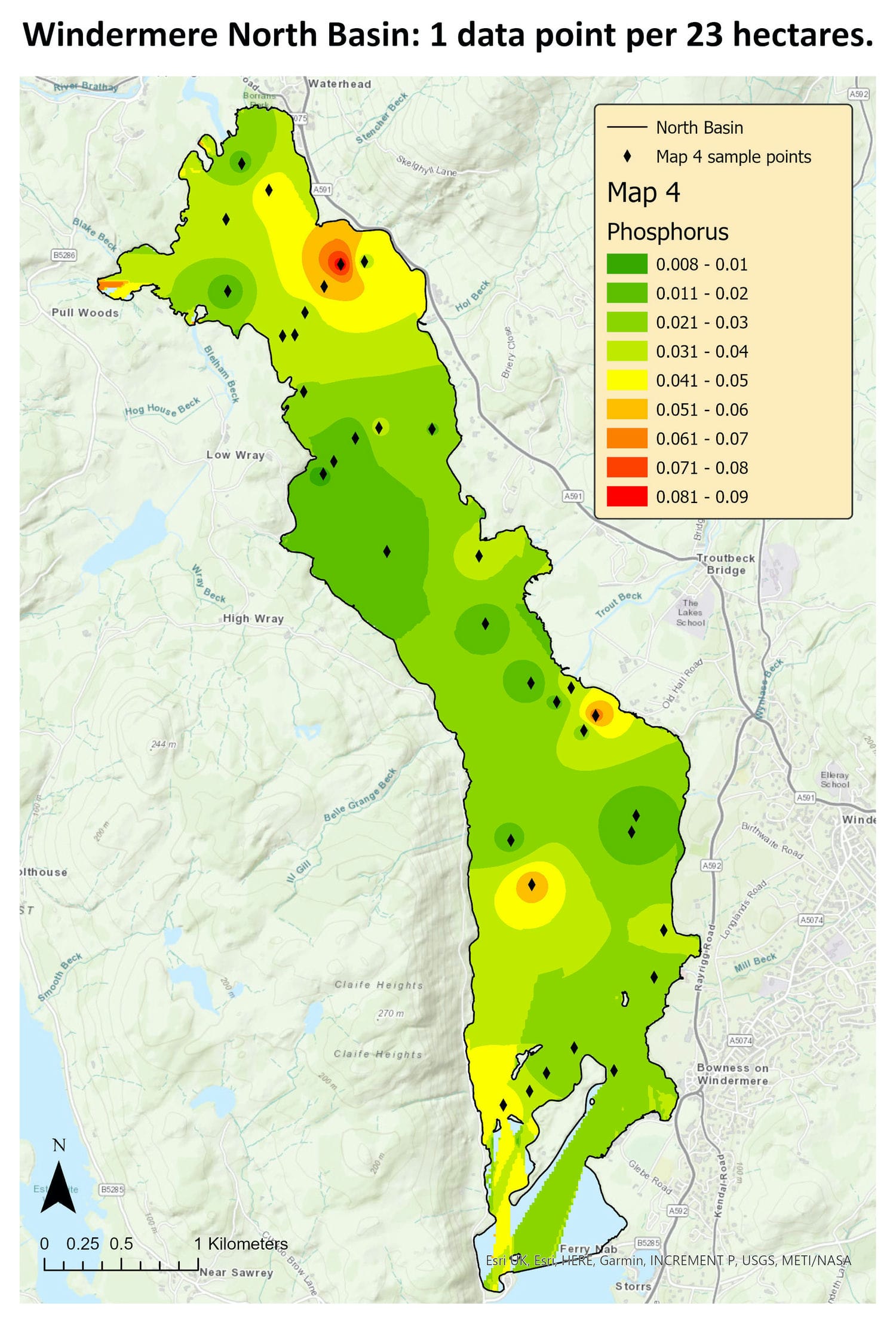
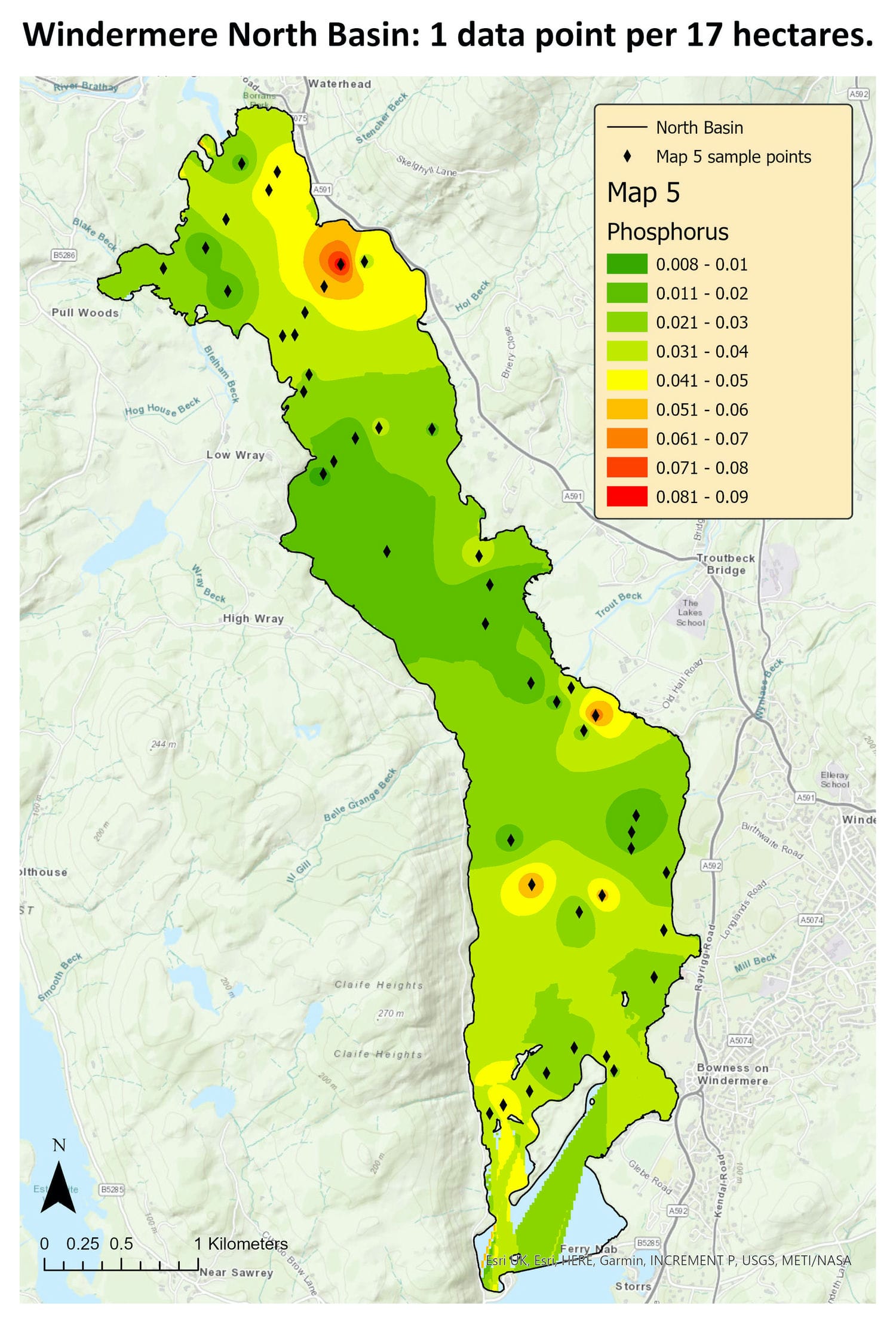
A Summary of Results
The results show that shoreline data alone was unrepresentative of the wider basin and that increasing sampling resolution significantly improved the spatial understanding of phosphorus concentrations in the Windermere North Basin. GIS maps produced from progressively larger datasets showed that low sampling densities resulted in substantial variation in predicted phosphorus distribution. However, from one data point per 23 hectares onwards, the spatial pattern stabilised, with minimal change observed in higher resolution models. This suggests that a sampling density of approximately one data point per 23 hectares is sufficient to provide an accurate representation of phosphorus concentrations across the North Basin.
Suitability analysis further supported this conclusion. As sampling resolution increased, the strength of the linear relationship between lower resolution datasets and the highest resolution dataset improved substantially. This confirms that higher sampling densities produce more reliable spatial representations, but that beyond a certain threshold, additional sampling yields limited improvement. This highlights the importance of basin wide sampling and demonstrates how GIS can be used to estimate the minimum effort required to effectively map nutrient concentrations in lakes across England.
What This Has Led To
I led the map work for the ‘Connect the mains: Report on non-mains drainage in the Windermere Catchment’, by the Save Windermere Campaign. It involved taking United Utilities reports and georeferencing the existing infrastructure boundaries into GIS.
Local and commercial building data was used alongside this to see which buildings were outside of the existing sewage treatment works. Example routes that could connect the outlying buildings were mapped and then the Save Windermere Campaign put this forward to United Utilities.
Additional GIS support focused on sewer route planning. Alongside mapping proposed sewer routes, I produced elevation profiles for each route to assess feasibility, identify gradient constraints, and inform potential pumping station locations.
The project also included preliminary cost estimation using route lengths and per-metre pipe costs, providing an initial indication of financial viability. In addition, I digitised annotations from paper maps into GIS formats, enabling clearer, more efficient communication and improved integration with other spatial data.
